Most Rare Natural Beauty

This is a list of the most original of which are specific for its natural beauty, some demographic characteristics, and some of the tourist features. Were taken into account only to sovereign states.


A country with 3 million lakes – Canada.

In Canada, there are more than 60 percent of lakes in the world, they are so numerous that their exact number is unknown. In some regions, for every 100 square meters. km for more than 30 lakes.


The country in which more than 17,500 islands – Indonesia

Indonesia consists of more than 17 500 islands with a total coastline of 81,350 km. Approximately 6,000 of the islands are inhabited. The largest islands – Java, Sumatra, Borneo, Sulawesi, Bali, Lombok and Flores. Indonesia contains 10-15 per cent of coral reefs in the world.


Country Desert – Libya

Libya – a country with the highest percentage of the Desert (99%). Libyan Desert, which covers most of Libya, is one of the driest places on Earth. In some areas can go decades without rain, and even in the high rainfall are rare, once in 5-10 years.


The country with the lowest population densities – Mongolia

The country with the lowest population density in the world is Mongolia, population density, about 4.4 people per square mile (1.7 pers. / Km). In Mongolia, the 2.5 million people occupy more than 600,000 square miles of land (approximately 1.56 million sq. km.) Most of this population lives in urban areas as the development in the vast deserts of Mongolia grassland is difficult, particularly because of the drought and dust storms, resulting in some parts of the country almost as well as desert and in time of Genghis Khan.


Country in the jungle – Suriname

The forest area is 14.8 million hectares (57 000 square miles), representing 91% of the total land area of Suriname (16.3 million hectares, or 63 000 square miles). The extensive forest of Suriname and the low population, about 400 thousand in the capital and coastal cities, give him one of the lowest rates of deforestation in the world. Only 5 percent of the population lives in tropical forests, it is indigenous tribes and six blacks – descendants of runaway slaves who recreated forest communities centuries ago and today retain their traditional West African style.


Dying is the country – Ukraine

Country with the highest fertility decline is Ukraine, with the natural population decline 0.8% each year. Ukraine is expected to lose 28% of its population in 2050 (from 46.8 million today to 33.4 million in 2050).


The country below sea level – the Netherlands

Half of the Netherlands lies below sea level. Live below sea level to more than 60 percent of the population of 15.8 million. Only in the area south of the Netherlands increased to 30 yards or more.


The most unfrequented country – Tuvalu

This is one of the smallest countries in the world. Tuvalu is located halfway between Australia and Hawaii, and is projected to be the first country to disappear under water when global warming will raise sea levels high enough. In addition, here it is very difficult and very expensive to get flights out of Fiji. Tuvalu visited a total of 1,100 tourists a year.


Country-continent – Australia

Australia is the only country in the world, which embraces the whole continent, in any other continent has more than one country. This is the only country which is a continent and a continent which is the country. This is the sixth largest country in the world, with a total area of ​​7686850 sq km (2967909 sq. miles), it is a little less than 48 U.S. states and in 31.5 times more than the United Kingdom.


Source


READ MORE»

Stunning Images from NASA's Operation IceBridge


The stunning coast of Greenland, complete with fjords, glaciers and sea ice.

NASA isn't always just about telescopes, sattelites and outer space. They also perform some very important research and monitoring work right here on planet Earth. One of their most important ongoing programmes is Operation IceBridge, aimed at finding the reasons behind polar ice melting and the rise in sea levels.

Through comprehensive data collection, they're trying to shed some light on the matter. From 2003, NASA utilised their ICEsat (Ice, Cloud and land Elevation Satellite) to take these measurements, but unfortunately in 2010 the satellite stopped working. Such important research couldn't stop, however, so NASA switched to the next best thing: airplanes.


Valley on the Antarctic Peninsula

Using a DC-8, and later a P-3 Orion fitted out with state-of-the-art technical equipment, NASA were able to carry on recording important information from specific areas in the Artic and Antarctic, furthering our understanding of global climate change. The ICEsat is scheduled to be up and running again from 2015 but until then, aircraft will continue to monitor our ice caps, taking some stunning photographs of the constantly changing landscape in the process.

This steep Antarctic valley is full of flowing ice, making its way own to what remains of the Larson B ice shelf (an area of ice floating on the sea). When that huge shelf, roughly the size of Rhode Island and stable for over 12,000 years, broke off and disintegrated in 2002, it was seen by many as incontrovertible proof of global warming. When the ice in this valley reaches the remnants of the ice shelf, it will break them up futher, pushing them out to sea as icebergs.


Crack in the ice at Pine Island Glacier

From this angle, it may not look like much, but that line across the middle of this picture is actually a crack in the ice and it's enormous. What you're seeing is a photo of the Pine Island Glacier ice shelf taken in October 2011. If the area of the ice shelf behind this fracture were to break off, it would mean 800 square kms (310 square miles) of ice breaking away, or 'calving'.

The Pine Island Glacier is made up of around 10% of the Antarctic ice sheet, itself the largest ice mass on Earth, and is one of the main areas of focus for Operation IceBridge. Large scale melting here would have major ramifications for sea levels around the world.


Pine Island Glacier ice shelf crack, seen from above

This close-up of the ice fracture gives some idea of its width and depth. This particular stretch is 240 feet wide, and NASA recorded the break descending to all the way down to sea level at some points. It is almost certain that the crack will widen and break off the ice behind it in the coming months. When this happens, scientists say that the Pine Island Glacier will have retreated to its fartherest level since 1940, when measurement of the glacier began.


Rugged mountains of southeast Greenland

On the opposite side of the world to the Antarctic lies Greenland. As part of the Arctic component of Operation IceBridge, NASA flew over vast territories here including the rugged southeast where they passed over many glaciers and fjords (inlets carved by millions of years of moving ice). The primary purpose here was to measure the worrying rate of melting in Greenland's ice sheets.


A Greenland Ice Stream

Like glaciers, ice streams are rivers of moving ice, usually lubricated by a layer of water underneath and reaching speeds of up to 1,000 meters a year. Trapped in this ice stream, large chunks of ice are being carried across the ice sheets of northeast Greenland towards their final destination, the sea.


The Jakobshan Glacier

Breaking off the end of West Greenland's Jakobshavn glacier are some monster- sized icebergs. Every year, over 35 billion tons of ice calve into the sea from this fast-moving glacier. Many of them are so large, they simply sit at the end of the glacier for years until they're broken up by continued pressure from the ice river behind them. Keeping track of this glacier is considered an important part of climate change study for Operation IceBridge.


Glacier and sea ice

Two mighty forces of nature come together as a glacier in West Greenland flows into and is absorbed by sea ice. Although composed of seawater, sea ice is actually converted into fresh water by the freezing process. Sea ice advances and retreats with the seasons, and is a barometer of earth's global tempratures. Fortunately for scientists, we have a good record of sea ice since 1978 when NASA began tracking it with satellites.


Russell Glacier

It's easy to see why Russell's Glacier is one of Greenland's favourite tourist sites. Scientists from Operation IceBridge have been studying the meltwater (seen here pooling on top of the ice) from this stunning frozen river in an effort to better understand where the runoff goes to and how this affects sea levels. Russell Glacier does not run directly into the sea, making it less vulerable to fluctuating ocean temperatures. The biggest loss of ice here comes instead from melting.


Mountains near Qaanaaq, formerly known as Thule

As well as being of vital scientific significance, Greenland is also a country of breathtaking beauty, as you can see from this stunning shot taken near Qaanaaq, its northernmost town. (Avid readers may recall that it was here that Smilla was born, in the bestselling book "Miss Smilla's Feeling for Snow.") The people of Qaanaaq live a lifestyle very much tied to their environment, hunting polar bears, narwhals and walruses for food as they have for generations. They would be among the first people affected by any changes in temprature due to global warming.


Wreckage of a B-29 in the snow

Although they were on a research mission, the scientists of Operation IceBridge did occasionally also pass over other interesing sites. Here lie the remains of a B-29 called Kee Bird, which crash landed in Greenland in 1947. Perhaps not such an inspiring sight to see from a plane.


Sea ice

Not only important for scientists monitoring global warming, sea ice also supports a diverse ecology including walruses, polar bears and sea lions to name just a few. NASA studies the Arctic seas around Alaska to gauge how environmental factors are affecting the chemistry of the ocean, the ice and those who depend on it.


Another view of sea ice

Seen from above, the pure snowy white of older sea ice contrasts strongly with the dark depths below the thin newly formed ice. New sea ice, still in its transparent stage, is known as 'nilas.' As water below the ice starts to freeze, it will take on a grey and finally white appearance. Awe-inspiringly beautiful but also vitally important, sea ice will continue to be a focus for Operation IceBridge, as they watch it slowly melt away.


Source


READ MORE»

What Ancient People Believes about Dinosaurs

Like cultures today, ancient people created artwork based on real-life subjects. Many cave paintings (pictographs) and petroglyphs (shallow rock carvings) depict scenes from battles (24), ancient people performing various rituals (36), (and fauna, such as buffalo, seen by the native peoples. Sculptures, mosaics, figurines, and carvings made by people hundreds or thousands of years ago also depict some strange creatures that seem to closely resemble what we might call dinosaurs. This leads to a fascinating question: Did ancient cultures believe that dinosaurs were contemporaries of humankind and did they claim to see such creatures?

The Acambaro Figurines

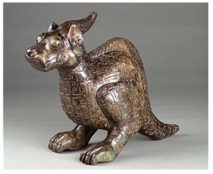
In the summer of 1944, a German merchant, Waldemar Julsrud, made a discovery that has caused a stir in the scientific community (35). It was July 1944 and Waldemar Julsrud was riding his horse along the lower slope of El Toro Mountain near the town of Acambaro, Mexico, when he noticed something unusual poking out of the dirt (35). Dismounting, he tore into the ground and unearthed a few ceramic objects unlike anything he had ever seen before (35). His discovery led to the excavation of over 33,500 ceramic, stone, and jade figurines and artifacts (35).

Charles Hapgood, a professor of anthropology and history at Keene State College, learned about the figurines and decided that he would see them for himself (35). After investigating and researching the figurines for 18 years, and after seeing more of the objects turn up when workers dug in certain locations he determined, Hapgood, a self-confessed skeptic (35), authored a book on the Acambaro figurines: Mystery in Acambaro: Did Dinosaurs Survive Until Recently? No longer a skeptic about the origin and authenticity of the ancient figurines, Charles Hapgood believes that they were made by an ancient culture. At the same place where the artifacts were discovered, the teeth of an extinct horse, the skeleton of a mammoth, and human skulls were also unearthed (35). The fact that many of these unique figurines resemble dinosaurs has been a reason the majority of the scientific community has ignored the discovery, passing it off as a hoax.

Shang Dynasty "Saurolophus"

Besides the major discovery in Acambaro, a number of other figurines from other ancient cultures have sparked debate or been ignored by the majority of the scientific community. An artifact from the Shang Dynasty is described by Genesis Park website as a creature that "displays relief lines in a scale-like pattern, a broad beak, a dermal frill, and a headcrest that is strikingly like the dinosaur Saurolophus ..." (1). According to Genesis Park, the dinosaur-like figure "was advertised on the Chinese antiquities market as a dinosaur depiction" (1). Concerning it's authenticity, Genesis Park declares that: "This jade statute, now in the Genesis Park collection, is made of white colored nephrite with differential weathering, cleaving veins and earth penetration, demonstrating authenticity …" (1).
Besides the Acambaro figurines and the Shang Dynasty saurolophus, there are more examples of possible dinosaur-like figurines from ancient cultures that could be mentioned such as the figurine of a Dogon tribesman, from Africa, riding a strange, "prehistoric" creature or the painted pots and vases from the Moche tribe of South America. According to Genesis Park, the Moche tribe ceramics display "with singular realism medical acts, combative events, musical instruments, plants and animals" (1). Some of these painted vases and pots have what appear to be realistic dinosaurs painted on their clay surfaces (1). The Moche tribe pottery collection is currently located in the Larco Herrera Museum in Peru (1).

The Ica Stones

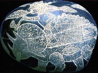
Besides clay, ancient humans used stone and metal to artistically record objects, events, or animals they had witnessed. They also carved images into individual rocks. An example of this can be found in the controversial Ica Stones discovered by Dr. Javier Cabrera outside of the town of Ica. Over the years, Dr. Cabrera had amassed a huge collection of stones with strange carvings in their surfaces depicting people and dinosaur-like creatures living together. Referring to Dr. Cabrera's collection, Josef F. Blumrich, a NASA scientist, said, "I am deeply impressed by what I have seen here, and I am happy to have found so much direct evidence of what I began to feel and understand before. There is not doubt in my mind about the authenticity of these stones" (10). Unfortunately, there is no way of scientifically determining whether or not the stones are ancient. Because of their controversial nature, Dr. Cabrera has received a lot of condescension by the scientific community (4).

The Granby Idol

A discovery made in 1920 by a rancher outside the town of Granby, Colorado bears the unique appellation "the Granby Idol". Bud Chalmers was removing rocks from his ranch one day when he lifted one that weighed more than he expected. Curious, he decided to wash it off. After the coating of dust and dirt had been removed, a set of grooves appeared in the rock. A crude, smiling face surrounded by strange symbols appeared on one side of the rock (22). On the reverse side of the stone, to Bud Chalmers amazement, the distinct carvings of a long-necked dinosaur and a woolly mammoth appeared (22). As an interesting note, Dr. Cyclone Covey, who wrote a book about the possibility that the ancient Chinese had come to America, studied photographs of the stone and identified the symbols carved into the stone as belonging to the ancient Chinese (22).

Mesopotamian Cylinder Seal

Another ancient artifact, created by carving into a stone chunk, that provides a clue that the ancients believed dinosaurs existed with them is a Mesopotamian cylinder seal, estimated to come from the year 3,300 B.C. (13). The seal displays two long-necked animals--that strikingly resemble modern renderings of a sauropod dinosaur--entwining their necks and tails. The shape of the muscles and length of the necks and tails of the creatures are remarkably realistic. One can only logically conclude that the artists who created the seal would have had to have seen either a representation of a dinosaur or a living specimen to make such an accurate depiction. The imagination alone could not produce such accuracy.

The Anasazi Dinosaur Petroglyph

Depictions of dinosaurs are not limited to figurines, stones, or cylindrical seals. Ancient dinosaur artwork has been found on cliff sides, on walls, and in buildings. Petroglyphs and pictographs made by ancient tribes depict strange creatures that do not match up with any that are known to exist today. In Natural Bridges National Monument, Utah, a very interesting petroglyph that resembles a sauropod (long-neck dinosaur) has raised eyebrows and questions. The petroglyph is attributed to the Anasazi Indians who lived in that area during the 1300s A.D. (15). Like the creators of the other relics mentioned above, the Anasazi Indians' ability to create such rock art could only be explained if the Anasazi Indians had actually seen a living dinosaur. The first complete dinosaur skeleton was discovered by William Parker Foulke in 1858, in Haddonfield, New Jersey (17). That is more than five-hundred years after the Anasazi Indian tribe left the area in which the dinosaur petroglyph was discovered.

The Water Panther Pictograms

Found on different cliff faces near the Great Lakes, another interesting native representation of a dinosaur-like creature draws the attention of curious hikers. The creature is called the water panther. The Sioux Indians believe that this creature inhabits the Missouri River. Vine Deloria, author of Red Earth, White Lies: Native Americans and the Myth of Scientific Fact, reports in his book what members of the Sioux tribe have said about the legendary creature. The creature had a backbone "just like a crosscut saw" and "in the middle of its forehead was one horn" (7). The pictograms of this creature show an animal with a jagged back similar to a dinosaur's back, and two horns protruding from its head. It looks strikingly like a triceratops, a member of the family Ceratopsidae, or a horned dinosaur of some kind.

Angkor Wat "Secret"

Representations of dinosaurs on large, flat surfaces are not limited to pictographs and petroglyphs on cliff sides. Some ancient buildings have eye-opening features either cut into or affixed to their walls and floors. One of the most clear examples of this can be found in the mysterious, ancient ruins of Angkor Wat. Richard Sobol, author of The Mysteries of Angkor Wat: Exploring Cambodia's Ancient Temple, wrote about his experience exploring the ancient temple. A group of kids he met wanted to show him a "secret" (29). They led him over to a rock wall filled with carvings. Richard Sobol writes, "I moved closer, and saw there, on the wall, carved inside a circle, a creature that could only be described as a dinosaur--a stegosaurus, in fact" (29). The image he took of the dinosaur, which is carved into a circle within the wall, resembles a stegosaurus. Whether or not it is a stegosaurus, it does have some of the distinct features of the family Stegosauridae: triangular plates on its back and tale, four muscular legs, a head attached to a short neck, a large body, and a thick tail.

The Tomb of Richard Bell

Another oddity is found in the tomb of a fifteenth-century bishop at Carlisle, Richard Bell. A brass fillet, dating back to the 1400s, runs around the perimeter of his tomb. Engraved into its metal surface are various animals such as a dog, a fish, an eel, a bird, a pig, etc (8). What is really intriguing is the engraving of what appear to be two long-necked creatures with long tails apparently struggling with each other. All the creatures in the tomb are fairly accurately portrayed, so it is most likely that these creatures were accurately portrayed as well (8). Having long necks, four legs, and thick, long tails, the creatures appear to be sauropods (8). No animal that we know of today fits that description.

The Nile Mosaic of Palestrina Mosaic

An incredible and yet very real mosaic from ancient Italy, the Nile Mosaic of Palestrina is a huge image that was originally set into the floor of the Sanctuary of Fortuna Primigenia, which is located in Palestrina, Italy (9). Currently located in the Museo Nazionale Prenestino in Rome (20), the Nile Mosaic of Palestrina displays various scenes from the Nile River, showing life in Egypt during the Roman Empire. This mosaic is notable not only for its historical value but also for its depictions of strange creatures. One creature clearly looks like a large dinosaur resting on a rock, and the human figures standing beside it are small in comparison.
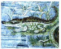
The "Hunt" Mosaic

A most intriguing mosaic from the same era was discovered in the ancient city of Pompeii, Italy. It was in the year 79 A.D., on the 24th of August, that Mount Vesuvius erupted, sending a hot cloud of vocanic ash through the city of Pompeii, preserving the ancient relics and artifacts within (9). It was from the house of a rich physician in this city that the "Hunt" mosaic was discovered. The mosaic shows people interacting with, or hunting, reptiles and large animals. The most unique aspect of this mosaic is the fact that the creatures are not normal animals one would expect to find. A man is riding atop a large reptile with vertical plates along the ridge of its back. The creature is not a poor fascimile of a crocodile because, elsewhere in the same mosaic, an accurately rendered crocodile is seen resting on a bank (9). Why more people are not aware of these amazing pieces of history appears to be due to an intentional suppression of the existence of these ancient Roman mosaics. If both these mosaics, all the abovementioned artifacts, engravings, and artwork were actually studied by unbiased scientists, historians, and other experts, and judged without any preconceived beliefs regarding the nature of the objects, then history books would likely have to be rewritten.

Considering the evidence above, a few questions emerge. Did ancient cultures believe that dinosaurs existed with humankind? Did ancient people actually see dinosaurs and encounter them? If so, did they tell their descendents what they witnessed?

Stories passed down by word of mouth--some of them originating apparently not that long ago--have come out of remote jungles and wilderness areas as western civilization has expanded to distant lands. Such information by word of mouth has come from the Australian Aboriginees, a people who have lived in the sub-continent for thousands of years. According to the Aboriginees, a number of large and powerful creatures once inhabited the vast expanse of Australia.

The Bunyip
In July 1845, and article appeared in the Geelong Advertiser of Victoria, Australia (12). It described the discovery of an un-fossilized bone of an unknown, giant animal. When the bone was shown to different, separate Aboriginal tribes, they all immediately identified it as a "bunyip" bone. The tribes were quite distant from each other and had no way of communicating with each other (12). According to their descriptions of the "bunyip", the animal was big, laid eggs, could walk on two feet, and was considered dangerous (Driver). According to the Aboriginees, the "bunyip" had "the characteristics of a bird and an alligator" (12). One native claimed that some deep scars in his skin were caused by a "bunyip" (12).

The Yarru

The Kuku Yalanji is a tribe located in rainforest of Far North Queensland, Australia (12). A missionary, Dennis Fields, learned from the elders of the Kuku Yalanji that a creature called the "Yarru" used to live in large waterholes in the rainforest (12). When Dennis Fields asked a tribal artist to paint the "Yarru" for him, the result was astonishing. The artist, who had no knowledge of what textbook dinosaurs or extinct creatures were supposed to look like, created a painting that was an accurate portrayal of what appeared to be a plesiosaurus (12). The painting was based entirely on the descriptions passed down to the tribal artist from ancient stories (12).

The Kultra
A creature that is described as a quadruped with a long neck and a long, pointed tail is said, by the Central Australian aboriginal tribes, to have lived in swamps which once covered the region. The Aborigines call this creature the "Kultra" (12). From the descriptions they give, it appears to be a type of sauropod.

The Mokele-mbembe
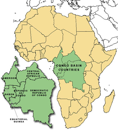
Thousands of miles away from the jungles of Australia, another rainforest spreads its leafy canopy over a vast area. The Congo Basin covers 1.5 million square miles with a swamp-filled jungle (3). Filling up a large portion of the Congo Basin, the Likouala Swamp is the largest swamp in the world (21). Covering roughly 55,000 square miles, an area larger than the state of Florida, the Likouala Swamp has been officially declared by the People's Republic of the Congo to be 80% unexplored (21). Over the years, starting in the year 1776 and up to the present time, people who have traveled to the Congo and talked to the native people have heard about a large creature that the natives call the "Mokele-mbembe" (21).


Various expeditions sent by different countries into the Congo have heard strange sounds coming from the jungle and have seen unusual footprints in the ground. A few have claimed to have actually seen the "Mokele-mbembe". In 1932, Gerald Russel, an animal trader, and Ivan T. Sanderson, a world famous zoologist at the time, were paddling up the Mainyu River in the Congo Basin. Suddenly, a large head, attached to a thick, "swan-like" neck, rose from the water (21). For a few seconds, the creature stared at the two men. Sanderson would later sum up his encounter with these startling words: "I don't know what we saw, but the animal, the monster, burned itself into my retinas. It looked like something that ought to have been dead millions of years ago. As a scientist, I should have been happy, of course, but this encounter was so frightening, so nasty that I never want to see it again" (21).
The natives describe the creature as being generally reddish-brown and about the size of an elephant, with a long neck and a long tail. It is known to devour plants and leave behind rounded tracts with three, prominent claws (21). Thus, it is a herbivore. These descriptions strongly suggest that the creature is a sauropod dinosaur (21).

The Thunderbird
Tribal people from Africa and Australia are not the only ones to have passed down stories about dinosaur-like creatures. Legends about large, scaly reptiles can be found in many ancient cultures. China, Europe, and the Middle East have tales about dragons. Though mythicized, the accounts of large reptiles capable of killing humans can hardly be the result of some highly imaginative people around the world who all happen to imagine very similar creatures. Though they do not have stories about dragons, Native American tribes, isolated from the rest of the world by giant oceans, have stories about dinosaur-like creatures. The Thunderbird is one such creature. The Thunderbird is claimed to have a huge wingspan and claws that it uses to pick up people. The belief is that the Thunderbird causes storms. Over the years many people have claimed to see a giant bird or pterodactyl flying through the air. As recently as the 2000s, people have claimed to have seen large, flying creatures. In the year 2001, several sightings of huge, "grayish-black", winged creatures were seen on June 13, July 6, and September 25, by various witnesses, in the state of Pennsylvania (32).

The Ogopogo

Besides the Thunderbird and the Water Panther (mentioned earlier), Native Americans also have another legend about a dinosaurian creature they called the "N'ha-A-Itk", which is commonly called the "Ogopogo". According to Native American legends about the N'ha-A-Itk, a "demon-possessed man" killed a tribal elder on the shores of a lake near his home (28). Completing his dastardly deed, he ran away, fearing retribution. Angered at the murderer, the gods captured the demon-possessed man, turned him into a "serpent", and cast him into the lake (which later was called Lake Okanagan) (28). He was to remain forever at the scene of the murder, as punishment. People who lived near the lake called the creature N'ha-A-Itk (28). It was later that the moniker Ogopogo was more commonly used, which was based on a line from an old song. To this day, sightings of a creature in Lake Okanagan have been reported (28). Besides Lake Okanagan, Lake Champlain, Lock Ness, and other lakes have had sightings of large creatures. Is it possible that some people actually have seen dinosaurian creatures in these lakes and have not been hallucinating or imagining what they have seen?
Ancient petroglyphs, pictographs, figurines, carvings, mosaics, stones, engravings, and legends on the subject of dinosaurian creatures are all interesting and intriguing pieces of possible evidence that dinosaurs may have (or possibly still do) lived as contemporaries of man. A question arises: If dinosaurs really had lived with humankind, explorers, scientists, or archeologists would most likely have found some remains or evidence to concretely prove it, correct?

Dakota
In 1999, Tyler Lyson, 16 at the time, was walking through the Hell Creek Formation badlands of North Dakota (25). His eyes locked onto a strange object protruding from a hill. As he looked at it longer, he realized it was a dinosaur bone. Five years later, excavation on the site began. On December 3, 2007, scientists announced to the world the discovery of a nearly intact, mummified hadrosaur, nicknamed "Dakota". According to an article from Wired.com, the dinosaur's "entire skin envelope appears to remain largely intact (25)." Phil Manning a paleontologist at University of Manchester (in England) who was leading the examination of "Dakota" said that the integrity of the skin envelope suggests that Dakota may have other "soft-tissue remnants" such as organs and muscles (25).
Leonardo


Discovered by a Judith River Dinosaur Institute expedition in the year 2000, and presented to the world in 2002, Leonardo is a duck-billed dinosaur (or a brachylophosaurus) that "will advance our science a quantum leap", according to Nate Murphy, curator of paleontology at the Phillips County Museum in Montana (18). The brachylophosaurus is estimated to have been either 3 or 4 years old when it died (37). Leonardo's muscles, skin, scales, foot pads, and a stomach are still intact. Skin scales and tissue have been found on less than a tenth of one percent of all the dinosaurs excavated over the years (18). Amazingly, 90 percent of Leonardo's skeleton is covered in soft tissue, such as a beak, nails, skin, and muscles (18). The actual tissue cells have been replaced by minerals, but the stomach contains a partially digested meal and scientists can actually see what exact plants the dinosaur had eaten (18). Ferns, magnolias, conifers, and the pollen of more than 40 different plants form the contents of the animal's stomach. It is likely that these all mineralized slowly over millions and millions of years without decaying?

B. rex

Discovered in the year 2000, the skeleton of a young, 18-year-old Tyranosaurus Rex (19) has drawn a lot of attention from scientists and laymen alike. The dinosaur skeleton was named "B. rex" after Bob Harmon, chief preparator of paleontology at the Museum of the Rockies, who discoverer it (2). Because the dinosaur was too large to take by helicopter, it had to be broken in pieces (19). As a result, a thighbone was cracked open and Mary Higby Schweitzer and her team were able to examine the interior of the bone (19). What they discovered has shaken the scientific community, causing scientists to reconsider their long-held beliefs about dinosaurs. Inside the bone were life-like tissues that should not have been inside a "65 million"-year-old Tyrannosaurus Rex (39). According to an article in Discover Magazine, Schweitzer found "supple bone cells, their three-dimensional shapes intact; and translucent blood vessels that looked as if they could have come straight from an ostrich at the zoo (39)." Hillary Mayell of National Geographic wrote about the discovery: "The vessels resemble blood vessels, cells, and the protein matrix that bodies generate when bones are being formed (19)." If the dinosaur was indeed 65 million years old, how could the actual cell tissues be preserved for so long? These tissues were not replaced by minerals and they were not mummified. Blood vessels, cells, and a protein matrix could hardly survive for a thousand years, much less a million. Is sixty-five million years with little decomposition possible?

The Age of B. rex

According to evolutionists, the earliest man (homo sapiens) existed in Africa nearly 200,000 years ago (23). The earliest form of civilization is considered, by evolutionists, to have come into existence 10,000 to 12,000 years ago (30). To get a picture of the length of time involved, imagine living to an old age of 100. Now, imagine, by some miracle, you keep going on and you make it to the age of 200. Say that scientists find a way to greatly extend human life spans and you get your life span extended so that you live a thousand of these 200-year-long life spans. You are now at an age equivalent to the time that has supposedly passed between the emergence of the earliest homo sapien and the present. You've live an incredibly long life. You've seen civilizations come and go, new buildings decompose into dust, animals become extinct, bodies die and rapidly decay into their constituent elements, and you've seen skeletons petrify. Now, imagine living 325 of these extremely long (200,000 year) life spans. You have finally reached the purported age of "B. rex". Think about all that time you spent and all the things you saw decay to dust. Does it make any sense at all that the cellular tissue within the bones of "B. rex" are millions and millions of years old? Is it possible that the methods evolutionists use to date dinosaur bones are erroneous?
When scientists at Oak Ridge National Laboratory used the Carbon dating method to find the age of some dinosaur bones, they came up with an age of only a few thousand years (31). Because this date did not fit their beliefs about the age of dinosaurs, they ignored their findings and decided to use other methods instead (31). Some of these results can differ from each other by as much as 150 million years (31).
Soft tissues normally decompose quickly after an organism dies (6).

Therefore, is it likely that blood vessels and soft tissues could continue to exist inside a dinosaur bone for millions of years? Scientists with evolutionary beliefs have scrambled to come up with a plausible and realistic explanation for how the soft tissue found within the thighbone of "B. rex" was preserved for what they assume to be 65 million years. So far, they have no explanation they all can agree on.


Conclusion
If one believes that dinosaurs died out millions of years ago, long before mankind came into existence, why does such an abundance of artifacts and legends on the subject of large, dinosaurian creatures, coming from ancient cultures around the world, exist? Is it possible that the figurines, stones, petroglyphs, pictographs, engravings, carvings, mosaics, and legends depicting and describing large reptile-like creatures are based on animals that ancient humans actually saw alive? Is it possible that our ancestors saw living dinosaurs and told stories about their encounters with the dinosaurs, passing down the tales by word of mouth? Could our methods for determining the age of dinosaurs be flawed? These are questions we need to ponder. The implications for the Theory of Evolution are numerous and profound. One such implication leads to an important question: Did humankind and dinosaurs live together instead of millions of years apart, as evolutionists claim? I leave my readers to come to their own conclusions based on the information presented in this article.


Source


READ MORE»

The oldest Metropolis on Earth was built by the Anunnaki?

The following discovery is of immense importance in our quest to find the TRUE human history. The article's author, Dan Eden, made a very fine job presenting the truth so I will mostly keep it as is. Of course, I will bring additions and connect the dots. This story will take you in a long journey, spanning for 450,000 years, interlocking events and puzzling together our financial history. Relax and enjoy!

They have always been there. People noticed them before. But no one could remember who made them -- or why? Until just recently, no one even knew how many there were. Now they are everywhere -- thousands -- no, hundreds of thousands of them! And the story they tell is the most important story of humanity. But it's one we might not be prepared to hear.

Something amazing has been discovered in an area of South Africa, about 150 miles inland, west of the port of Maputo. It is the remains of a huge metropolis that measures, in conservative estimates, about 1500 square miles. It's part of an even larger community that is about 10,000 square miles and appears to have been constructed -- are you ready -- from 160,000 to 200,000 BCE!

The title image is a close-up view of just few hundred meters of ladscape took with Google-Earth. The region is somewhat remote and the "circles" have often been encountered by local farmers who assumed they were made by some indigenous people in the past. But, oddly, no one ever bothered to inquire about who could have made them or how old they were.
The following pictures have the contrast enhanced to 150% and sharpened to level 7:


This changed when researcher and author, Michael Tellinger, teamed up with Johan Heine, a local fireman and pilot who had been looking at these ruins from his years flying over the region. Heine had the unique advantage to see the number and extent of these strange stone foundations and knew that their significance was not being appreciated.

"When Johan first introduced me to the ancient stone ruins of southern Africa, I had no idea of the incredible discoveries we would make in the year or two that followed. The photographs, artifacts and evidence we have accumulated points unquestionably to a lost and never-before-seen civilization that predates all others -- not by just a few hundred years, or a few thousand years... but many thousands of years. These discoveries are so staggering that they will not be easily digested by the mainstream historical and archaeological fraternity, as we have already experienced. It will require a complete paradigm shift in how we view our human history. " - Tellinger


Where it was found: The area is significant for one striking thing - GOLD!!! "The thousands of ancient gold mines discovered over the past 500 years, points to a vanished civilization that lived and dug for gold in this part of the world for thousands of years," says Tellinger. "And if this is in fact the cradle of humankind, we may be looking at the activities of the oldest civilization on Earth."

To see the number and scope of these ruins, I suggest that you use google-earth and start with the following coordinates:

Carolina: 25 55' 53.28" S / 30 16' 13.13" E

Badplaas: 25 47' 33.45" S / 30 40' 38.76" E

Waterval: 25 38' 07.82" S / 30 21' 18.79" E

Machadodorp: 25 39' 22.42" S / 30 17' 03.25" E

Then perform a low flying search inside the area formed by this rectangle. Simply Amazing! Remember, we're talking almost 200,000 years ago!

The individual ruins [see below] mostly consist of stone circles. Most have been buried in the sand and are only observable by satellite or aircraft. Some have been exposed when the changing climate has blown the sand away, revealing the walls and foundations.


(Contrast 200%, darkened)

"I see myself as a fairly open-minded chap but I will admit that it took me well over a year for the penny to drop, and for me to realise that we are actually dealing with the oldest structures ever built by humans on Earth.

The main reason for this is that we have been taught that nothing of significance has ever come from southern Africa. That the powerful civilizations all emerged in Sumeria and Egypt and other places. We are told that until the settlement of the BANTU people from the north, which was supposed to have started sometime in the 12th century AD, this part of the world was filled by hunter gatherers and so-called Bushmen, who did not make any major contributions in technology or civilization." - Tellinger

A Rich and Diverse History
When explorers first encountered these ruins, they assumed that they were cattle corals made by nomadic tribes, like the Bantu people, as they moved south and settled the land from around the 13th century. There was no previous historical record of any older civilization capable of building such a densly populated community. Little effort was made to investigate the site because the scope of the ruins was not fully known.


Over the past 20 years, people like Cyril Hromnik, Richard Wade, Johan Heine and a handful of others have discovered that these stone structures are not what the seem to be. In fact these are now believed to be the remains of ancient temples and astronomical observatories of lost ancient civilizations that stretch back for many thousands of years.

These circular ruins are spread over a huge area. They can only truly be appreciated from the air or through modern sattelite images. Many of them have almost completely eroded or have been covered by the movement of soil from farming and the weather. Some have survived well enough to reveal their great size [see above] with some original walls standing almost 5 feet high and over a meter wide in places.


(Contrast 200%, Sharpened level 5)

Looking at the entire metropolis, it becomes obvious that this was a well planned community, developed by a highly evolved civilization. The number of ancient gold mines suggests the reason for the community being in this location. We find roads -- some extending a hundred miles -- that connected the community and terraced agriculture, closely resembling those found in the Inca settlements in Peru.

But one question begs for an answer -- how could this be achieved by humans 200,000 years ago?


(Contrast 200%, Sharpened level 3)

This is what you will see on google-earth at:
25 37'40.90"S / 30 17'57.41E [A].
We are viewing the scene from an altitude of 357 meters.

This is not a "special" location -- just one we picked at random, within the previously described area. It shows artifacts that are everywhere and we encourage you to search the area with this great internet technology.

The circular stone structures are obvious from this view, even though they may not be visible from ground level. Notice that there are many very long roads [B] that connect groups of the circular structures. If you zoom out and follow these "roads" they travel for many miles.

The fact that we can see these structures is mainly because natural erosion has blown away the dirt and debris that has covered them for thousands of years. Once exposed to the wind, the rocks are scoured clean and may appear deceptively new.

If you look closely at what first appears to be empty land [C], you will notice many faint circles, indicating that even more dwellings lurk below the surface. In reality, the entire area is packed full of these structures and connecting roads.

How was the site dated
Once the ruins were examined, the researchers were anxious to place the lost civilization in a historical perspective. The rocks were covered with a patina that looked very old but there were no items sufficient for carbon-14 dating. It was then that a chance discovery revealed the age of the site, and sent a chill down the spine of archaeologists and historians!

Astonishing discovery: A massive stone calendar aligned with Orion's belt!

Finding the remains of a large community, with as many as 200,000 people living and working together, was a major discovery in itself. But dating the site was a problem. The heavy patina on the rock walls suggested the structures were extremely old, but the science of dating patina is just being developed and is still controversial. Carbon-14 dating of such things as burnt wood introduces the possibility that the specimens could be from recent grass fires which are common in the area.

The breakthrough came quite unexpectedly. As Tellinger describes it:

"Johan Heine discovered Adam's Calendar in 2003, quite by accident. He was on route to find one of his pilots who crashed his plane on the edge of the cliff. Next to the crash site Johan noticed a very strange arrangement of large stones sticking out of the ground. While rescuing the injured pilot from about 20 metres down the side of the cliff, Johan walked over to the monoliths and immediately realised that they were aligned to the cardinal points of Earth - north, south, east and west. There were at least 3 monoliths aligned towards the sunrise, but on the west side of the aligned monoliths there was a mysterious hole in the ground - something was missing.

After weeks and months of measuring and observations, Johan concluded that it was perfectly aligned with the rise and fall of the Sun. He determined the solstices and the equinoxes. But the mysterious hole in the ground remained a big puzzle. One day, while contemplating the reason for the hole, the local horse trail expert, Christo, came riding by. He quickly explained to Johan that there was a strange shaped stone which had been removed from the spot some time ago. Apparently it stood somewhere near the entrance to the nature reserve.

After an extensive search, Johan found the anthropomorphic (humanoid shape) stone*. It was intact and proudly placed with a plaque stuck to it. It had been used by the Blue Swallow foundation to commemorate the opening of the Blue Swallow reserve in 1994. The irony is that it was removed from the most important ancient site found to date and mysteriously returned to the reserve - for slightly different reasons."

* For me, the anthropomorphic stone it clearly indicates a non-human being. We know from many cultures (including the African culture that evolved from these places) that the humans were not allowed to depict the reptilians in their true form. So this is the perfect depiction of a reptilian standing next to/looking at the Orion's belt. He clearly is a non-human belonging to the stars.


The exact location of the calendar is listed on www.makomati.com. The first calculations of the age of the calendar were made based on the rise of Orion, a constellation known for its three bright stars forming the "belt" of the mythical hunter.

The Earth wobbles on its axis and so the stars and constellations change their angle of presentation in the night sky on a cyclical basis. This rotation, called the precession completes a cycle about every 26,000 years. By determining when the three stars of Orion's belt were positioned flat (horizontal) against the horizon, we can estimate the time when the three stones in the calendar were in alignment with these conspicuous stars.

The first rough calculation was at least 25,000 years ago. But new and more precise measurements kept increasing the age. The next calculation was presented by a master archaeoastronomer who wishes to remain anonymous for fear of ridicule by the academic fraternity. His calculation was also based on the rise of Orion and suggested an age of at least 75,000 years. The most recent and most acurate calculation, done in June 2009, suggests an age of at least 160,000 years, based on the rise of Orion - flat on the horizon - but also on the erosion of dolerite stones found at the site.

Some pieces of the marker stones had been broken off and sat on the ground, exposed to natural erosion. When the pieces were put back together about 3 cm of stone had already been worn away. These calculation helped assess the age of the site by calculating the erosion rate of the dolerite.


(In the left corner we can see the anthropomorphic stone depicting the reptilian standing next to Orion's belt. Also notice how tall he is).

If you payed attention to all my articles you will notice a trend. No matter what culture we study, everything goes back to this trio:

1. The Anunnaki Reptilians or other Reptilian/Serpent/Dragon gods;
2. The Orion's Belt;
3. The Pleiades Constellation;

This trio forms a more complex interlocking chain: Nibiru - Anunnaki - The Ancient Egypt - (now) Africa - The Illuminati worship - Vatican - Orion - Pleiades - Ritualistic worship - Temples and pyramids.


The truths in South Africa are preserved by Zulu Shamans and passed on from generation to generation.

David Icke met in his journeys a South African Shaman Zulu named Credo Mutawa. This wonderful person tells the story of the first African gods. They were Reptilian Extraterrestrials who came to Africa to mine gold. Because they needed workers, they genetically created the first human beings as their slaves. They had also interbreed with human women creating a superior race of leaders. These leaders (half blooded kings) were the bridge between the reptilian ETs and the African people.

Credo Mutawa also had a very old necklace telling the story of their first days on Earth. On the necklace there is a reptilian being that interbreeds with woman, a flying disc (genereically known as UFO), the Star of David (the possible explanation of Wayne Herschel is that the Star of David means, as in Heavens so on Earth. And refers to the Reptilian arrival on Earth.), the Orion's belt and many other figures.

You can see Credo Mutawa bellow, with a reptilian depiction (as he sees them) and the inherited necklace:


After Icke's interviews, Credo Mutawa was tortured and the necklace stolen. Behind the criminals was a white man that Credo never saw before.

This wonderful person also tells the already well known story (from all other civilizations), that the African people didn't had the right to depict the Reptilians in their reptilian shape. Those who broke this rule were killed by the reptilians.
Again, ALL civilizations have almost the same story. How could thousands of miles apart civilizations have the same stories of our creation and the reptilian gods?

GOLD MINING - HOW LONG AGO?
Is there evidence that mining took place, in southern Africa, during the Old Stone Age? Archaeological studies indicate that it indeed was so.

Realizing that sites of abandoned ancient mines may indicate where gold could be found, South Africa's leading mining corporation, the Anglo-American Corporation, in the 1970s engaged archaeologists to look for such ancient mines. Published reports (Optima) detail the discovery in Swaziland and other sites in South Africa of extensive mining areas with shafts to depths of fifty feet. Stone objects and charcoal remains established dates of 35,000, 46,000, and 60,000 B.C. for these sites. The archaeologists and anthropologists who joined in dating the finds believed that mining technology was used in southern Africa "during much of the period subsequent to 100,000 B.C."

In September 1988, a team of international physicists came to South Africa to verify the age of human habitats in Swaziland and Zululand. The most modern techniques indicated an age of 80,000 to 115,000 years.

Regarding the most ancient gold mines of Monotapa in southern Zimbabwe, Zulu legends hold that they were worked by "artificially produced flesh and blood slaves created by the First People." These slaves, the Zulu legends recount, "went into battle with the Ape-Man" when "the great war star appeared in the sky".


Source


READ MORE»