Lake Takepo, New Zealand

Lake Tekapo is the second-largest of three roughly parallel lakes running north–south along the northern edge of the Mackenzie Basin in the South Island of New Zealand. The Lake is a photographer’s dream come true, with snow-topped mountains, turquoise blue lake and a captivating beautiful little church. Every year from mid-November to December, the beauty is enhanced by a colourful display of Lupins.

Russell lupine (Lupinus polyphyllus) is an exotic plant that can grow up to 1.5 metres. It is a perennial species – that is, it flowers and sets seed in the summer, dies back to the stem base over winter, to re-emerge the following summer. Russell lupines produce long, colourful flower heads. The flowers are pea-like and come in a variety of colours - blue, purple, orange, yellow, pink, white or a mixture of two colours. The leaves, divided into green leaflets, are splayed out like fingers on a hand. Stout seedpods are produced that explode in the summer heat, releasing many dark brown seeds.


The Russel Lupins were introduced in the 1950′s by Connie Scott of the nearby high country station of Godley Peaks, when the seed was scattered along the exposed sides of the main highway. These tall spikes of colour now grow in abundance along many roadsides, open areas around the the village, and throughout the scenic Mackenzie country. The variety of colours make the already stunning lake Tekapo area a photographers paradise.


Sources
READ MORE»

Lake Natron

Lake Natron is a salt lake located in northern Tanzania, close to the Kenyan border, and just north east of the Ngorongoro Crater, in the eastern branch of Africa's immense Great Rift Valley. Nestled between rolling volcanic hills and deep craters, Lake Natron sits at the lowest point of the rift valley – 600m above sea level – and is probably the world's most caustic body of water.

The lake is fed by the Southern Ewaso Ng'iro River and also by mineral-rich hot springs. It is quite shallow, less than three meters (10 feet) deep, and varies in width depending on its water level, which changes due to high levels of evaporation, leaving concentrations of salt and other minerals, notably sodium carbonate (natron). The surrounding country is hot and often very dry and dusty – not very conducive to travel. But for those who do choose to visit Natron, they are rewarded with some of the most dramatic scenery they have ever see in Tanzania. It is said, that the journey alone is worth it for the views.


The lake has a deep red color characteristic of those where very high evaporation rates occur. As water evaporates during the dry season, salinity levels increase to the point that salt-loving microorganisms begin to thrive. Such halophile organisms include some cyanobacteria that make their own food with photosynthesis as plants do. The red accessory photosynthesizing pigment in the cyanobacteria produces the deep reds of the open water of the lake, and orange colors of the shallow parts of the lake. The alkali salt crust on the surface of the lake is also often colored red or pink by the salt-loving microorganisms that live there.

The high temperature (up to 41°C) and the high and very variable salt content of the lake does not support wildlife. However it is an important habitat for flamingos and is home to endemic algae, invertebrates and round the margins even fish that can survive in the slightly less salty water.

The lake is the only regular breeding area in East Africa for the 2.5 million Lesser Flamingoes, whose status of "near threatened" is a consequence of their dependence on the single breeding location. As salinity increases, so do the number of cyanobacteria, and the lake can support more nests. These flamingoes, the single large flock in East Africa, gather along saline lakes in the region, where they feed on Spirulina (a blue-green algae with red pigments). Lake Natron is a safe breeding location because its caustic environment is a barrier against predators trying to reach their nests on seasonally-forming evaporite islands.


Source
READ MORE»

Strange Landscape of Deadvlei Namibia

The picture below is not that of a painting. It was taken inside the Namib-Naukluft Park in Namibia, in a strange and alien landscape called Dead Vlei. Although sounds similar to “dead valley”, Dead Vlei is not an actually valley. The term means "dead marsh" (from English dead, and Afrikaans vlei, a lake or marsh in a valley between the dunes).

Deadvlei is a white clay pan located near the more famous salt pan of Sossusvlei, scattered with hundreds of dead Acacia trees that once thrived when water from the Tsauchab River soaked this piece of land. Some 900 years ago the river diverted its course, leaving Dead Vlei literally high and dry. Dead Vlei has been claimed to be surrounded by the highest sand dunes in the world, the highest reaching 300-400 meters which rest on a sandstone terrace.


The clay pan was formed after rainfall, when the Tsauchab river flooded, creating temporary shallow pools where the abundance of water allowed camel thorn trees to grow. When the climate changed, drought hit the area, and sand dunes encroached on the pan, which blocked the river from the area. The trees died, as there no longer was enough water to survive. There are some species of plants remaining, such as salsola and clumps of nara, adapted to surviving off the morning mist and very rare rainfall. The remaining skeletons of the trees, which are believed to be about 900 years old, are now black because the intense sun has scorched them. Though not petrified, the wood does not decompose because it is so dry.

The stunning picture was made at dawn when the warm light of the morning sun was illuminating a huge red sand dune dotted with white grasses while the white floor of the clay pan was still in shade. It looks blue because it reflects the color of the sky above. “Because of the contrast between the shady foreground and the sunlit background I used a two-stop graduated filter which reduced the contrast”, said photographer Frans Lanting. “The perfect moment came when the sun reached all the way down to the bottom of the sand dune just before it reached the desert floor. I used a long telephoto lens and stopped it all the way down to compress the perspective.”


Source
READ MORE»

Sea Launch

The two giant ships, a NASA-like mission control and a launch pad floating on the ocean, form part of an audacious, outrageously expensive, multi-national venture for blasting commercial satellites into space. Sea Launch was established in 1995 as a consortium of four companies from Norway, Russia, Ukraine and the United States, managed by Boeing with participation from the other shareholders. Operated by the Russians, this commercial spacecraft launch service uses a mobile sea platform for equatorial launches of payloads on specialized Zenit 3SL rockets. Since the first rocket flight on March 1999, it has assembled and launched thirty-one rockets, with three failures and one partial failure.


But why launch from the sea when there are land based launching sites, you may ask? Launching from a vessel allows engineers to move the launch pad closer to the equator of the earth, and take advantage of the greater rotational speed of the Earth to provide an extra boost to the launch. Earth’s rotation speed at the equator is 1,674 km/hr. In contrast, the rotational speed of the Earth at Kennedy Space Center, for example, which is located at 28.59° North latitude, is 1,470.23 km per hour. Rockets launched from near the equator thus gains an additional 200 km/hr boost, compared to those launched from Kennedy Space Center.

Launching satellites into geosynchronous orbit (allowing the satellite to keep pace with the earth's rotation) from the equator has another advantage: there is no need to change plane, as the satellites are launched from the same plane as that of the geostationary orbit. This provides another boost as no energy is spent orienting the vehicle. This allows 17.5%-25% more mass to be launched to geostationary orbit than the same rocket launched from Kennedy Space Center.

The ship and launch platform operate from the home port in Long Beach, California., where the customer satellite is encapsulated in a Boeing-built fairing/adapter. The satellite is moved to the ship, where it is mated to the three-stage rocket, which then is moved to the launch platform for transportation to the launch site, where it is moved into upright position. The rocket is automatically fueled and launched as engineers and customers control events from the nearby command ship.


Source
READ MORE»

Children Risking Their Lives to Reach School

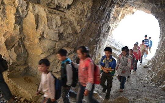
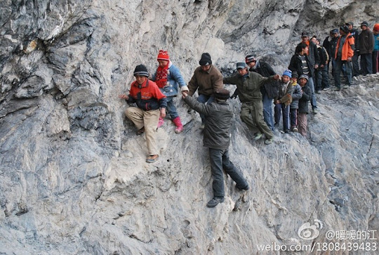
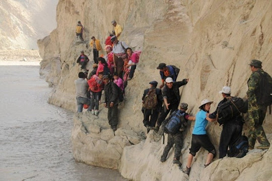
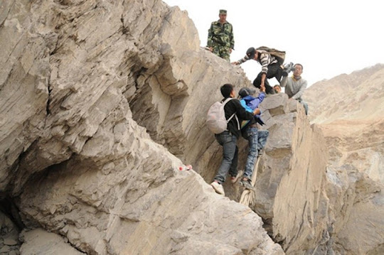
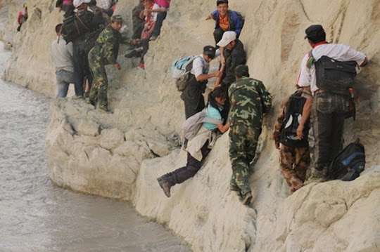
For most parents and kids, crossing the street to catch the school bus is perhaps the riskiest part of the school run. But take a look at these Chinese schoolchildren from the village of Genguan. Everyday, these young kids walk along a precarious path carved by the side of a cliff, as they make their way to class in Bijie, in southwest China's Guizhou Province. Banpo Elementary School is located halfway up a mountain and the path to it winds through treacherous hillside passes and tunnels hewn out of the rock. The pebble-covered footpath is less than 0.5 meters wide, which means the children have to walk single file and press themselves into the side of the mountain if someone wants to squeeze past. This footpath was created 40 years ago as an irrigation ditch and although there is another safer route, but taking this means the children have to spend two hours to walk to school. The only assurance for parents is that Headmaster Xu Liangfan accompanies the 49 kids to school.


The story might sound incredible to some, but it isn’t uncommon for children from less privileged regions facing immense hardship on their commute to the institute of learning. You will be surprised at the great lengths some children are willing to go to reach school.


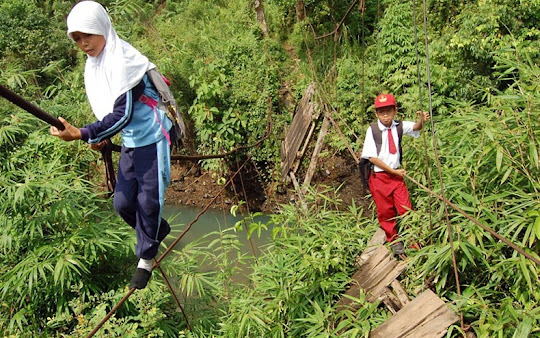
In Sumatra, Indonesia, about 20 strong-willed pupils from Batu Busuk village have to tightrope walk 30 feet above a flowing river to get to their class on time and then walk a further seven miles through the forest to their school in the town of Padang. The kids have been doing the balancing act for the last two years since the suspension bridge collapsed in heavy rain.


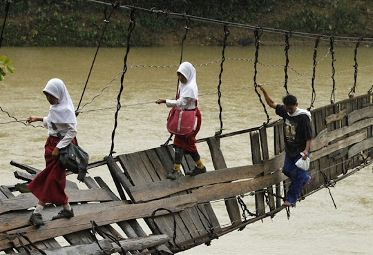
In another Indonesian village of Sanghiang Tanjung, children living on the wrong side of of the Ciberang River has to cross a broken suspension bridge to reach the other side where their school is located. Faced with an extra 30 minutes' walk to cross via an alternate bridge, the children have chosen to undertake the precarious crossing of the collapsed bridge instead.

The good news is: Indonesia’s largest steel producer, PT Krakatau Steel and some NGOs build a new bridge to replace one that was damaged after flooding in January 2012.


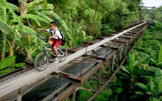
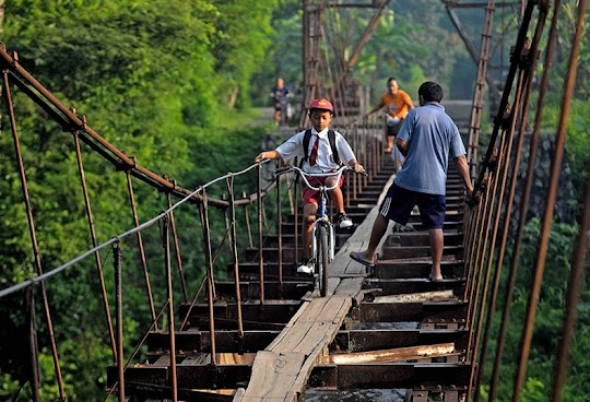
In yet another Indonesian village, children cycle their way over an aqueduct that separates Suro Village and Plempungan Village in Java, Indonesia. The children decided to use the aqueduct on their journey to school as a shortcut, even though it wasn't made for people to walk on. Even though it is dangerous, the children say would rather use it than walk a distance over six kilometers.


In Filipino, elementary school students use an inflated tire tube to cross a river on their way to school in a remote village in Rizal province, east of the capital Manila. The students have to walk for at least an hour a day to get to and from school, and are sometimes forced to skip classes or take shelter at relatives' homes if the river is swollen due to heavy rains. The community has been petitioning the local government to put up a suspension bridge in order to make the crossing easier, faster and safer.


The Filipino kids at least have tubes. These Vietnamese students aren’t so fortunate. Dozens of young children from grade 1 to grade 5 swim twice a day across the river in order to get to school at Trong Hoa commune, Minh Hoa district. In order to keep the clothes and books from getting wet, the students put them in large plastic bags and tightly sealed while crossing the river almost naked. These plastics bags were also being used to keep them afloat while swimming across the river. Upon reaching the other side of the river, they take their clothes out of the bag and put them on. The river is 15 meters wide and reportedly 20 meters deep.


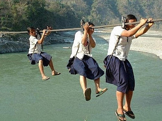
Gondola bridges are common in the mountainous country of Nepal where good roads are in short demand. Children use handcrafted bridges made with planks, improvised ropes and pulleys, without safety harnesses and double security restraint. For decades, this lack of security has caused numerous accidents. Fortunately, several NGOs are currently concerned with building safe bridges and gondolas to mitigate accidents.


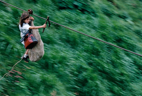
In Columbia, kids from a handful of families living in the rainforest, 40 miles southeast of the capital Bogota, commute via steel cables that connect one side of the valley to the other. This is the only way to reach school. The steel cables are 800 meters in length are strung 400m above the roaring Rio Negro.

Photographer Christoph Otto clicked this incredible picture of Daisy Mora and her brother Jamid, making their way at a breakneck speed of 50 miles per hour. She attaches the sack containing her brother, who is too young, at five, to make the crossing alone, and herself to a pulley. A branch in the shape of a wishbone forms a crude brake. The entire journey takes 60 seconds.


Back in China, around 80 school children who live in the boarding school at Pili, have to embark on a perilous 125-mile journey through the mountains of the remote Xinjiang Uighur Autonomous Region, at the end of their term. The children must also wade through four freezing rivers, cross a 650ft chain bridge and four single-plank bridges. The journey takes two days to complete.


Finally, here is one striking picture captured by Reuter photographer Ammar Awad in 2010. During clashes between Israeli troops and Palestinians in the refugee camp Shuafat, near Jerusalem, a girl is seen calmly walking towards her school unconcerned by the violence around her. The street is strewn with rocks thrown by protesters in the direction of the Israeli troop who can be seen behind the girl in protective shields. 


These pictures puts into a different perspective the whining complains of students about “having to go to school,” not bringing pencils or paper, and not making it to class on time. Ed Darrell, who blogs at Millard Fillmore's Bathtub, questioned: What value does this girl and her family place on education? Is education a civil right? Is education a basic human right?


Source
READ MORE»