Fort Drum - The Concrete Battleship

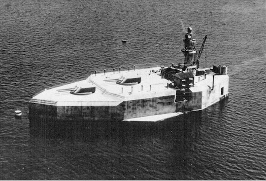
At the mouth of Manila Bay just off the coast of Philippines lies a huge battleship-shaped immovable concrete structure that was built in the early twentieth century to defend Manila. Known as Fort Drum, but commonly referred to as the “concrete battleship,” this heavily fortified structure roughly resembles a concrete ship. Fort Drum stands on an originally barren rocky island called El Fraile that was leveled by the U.S Army between 1909 and 1914, and built up with thick layers of steel reinforced concrete into a massive fortress, 350 feet long, 144 feet wide, and rising 40 feet above the water.


The idea of Fort Drum was created after the Spanish–American War in 1898 when the Board of Fortifications decided that the United States needed to better fortify overseas territories, especially harbors. One of the primary areas that the Board of Fortification decided to focus on was Manila Bay in the Philippines. Originally, the fort was to be the control center for a mine network across the Bay. However, due to inadequate defenses in the area, a plan was devised to level the island and then build a massive fortification.

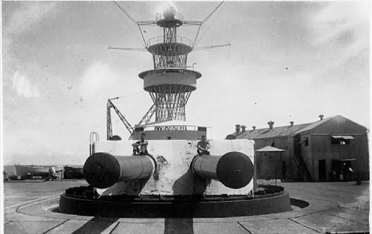
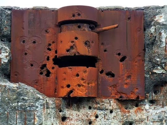
The fort was topped with a pair of armored steel gun turrets, each mounting two 14 inch guns. Searchlights, anti-aircraft batteries, and a fire direction tower were also mounted on its upper surface. Armor was provided by 25- to 36-foot thick fortress walls that protected extensive ammunition magazines, machine spaces, and living quarters for the 200 man garrison.

After the outbreak of war in the Pacific on December 7, 1941 Fort Drum withstood heavy Japanese air and land bombardment as it supported U.S. and Filipino defenders on Bataan and Corregidor. Fort Drum surrendered to Japanese forces following the fall of Corregidor Island on May 6, 1942 and was subsequently occupied by Japanese forces.

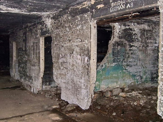
In a bid to recapture Manila, Fort Drum was assaulted by US forces on April 1945. After a heavy aerial and naval bombardment, US troops gained access to the deck of the fort, and were able to pin down the garrison below. But rather than attempting to break in, the troops pumped fuel into the air vents of and ignited it. The Japanese inside the fort were completely incinerated, while the fort burned for several days. When the Americans could enter the fort, they discovered 65 charred bodies.

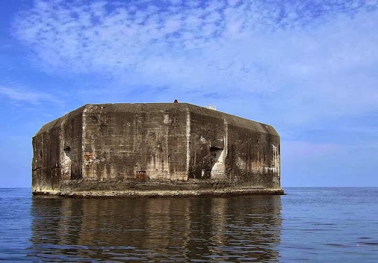
With the bay forts, including Fort Drum, thus neutralized, Japanese resistance in the Manila Bay area was ended. The ruined hulk of Fort Drum, including its disabled turrets and 14 inch guns, still stand at the mouth of Manila Bay.


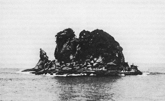
El Fraile Island before the building of Fort Drum


Starboard beam view of the battleship USS NEW JERSEY (BB-62) passing between CORREGIDOR (background) and FORT DRUM as she enters Manila Bay. Date: 3 Jul 1983


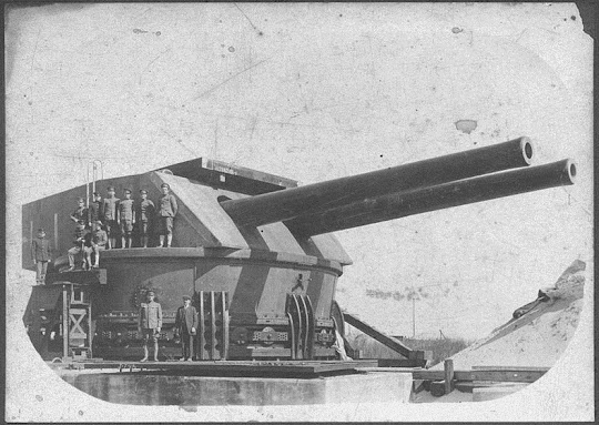
14-inch turret for Fort Drum undergoing tests a Sandy Hook proving ground.
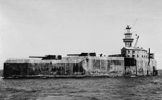

Fort Drum in 1937.


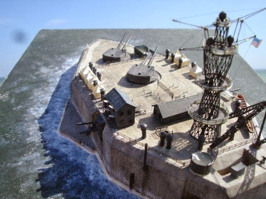
Computer generated 3D model of Fort Drum


Source
READ MORE»

The Giant Gippsland Earthworm

In the 1870s, surveyors around Warragul found an animal that they thought may have been a snake. They sent it to the then Director of the National Museum of Victoria, Professor Frederick McCoy, who described it as a new species of earthworm and named it Megascolides australis. Its common name is the Giant Gippsland Earthworm.


Although the body lengths of adult specimens average around under one metre, the body can expand and contract, and lengths of over two metres have been recorded. However, body length is not an accurate measure of size, and fresh body weight is more reliable; adults average around 200 g.
Where does it live?

Even though it is a large species, it is not often seen because it lives deep in the soil and never comes to the surface unless flushed out by heavy rain. It is also very restricted in its distribution. It is only found in the Bass River Valley of South Gippsland, in an area of about 100,000 hectares bounded by the towns of Loch, Korumburra and Warragul. However, within that area, it is very patchy in its distribution and is found in a particular type of blue-grey clay within a short distance of water courses, soaks and springs.


The worm burrows can occur from just below the soil surface to a depth of 1-1.5 m with the worms occurring at a median depth of about half a metre. The Giant Gippsland Earthworm, like any other species of native Australian earthworms, leaves its casts underground in its burrows, and the conical shaped entrances to land crayfish burrows are often mistakenly identified as earthworm casts.
Why is it on the Endangered Species List?

Before European settlement, South Gippsland was predominantly covered by tall, wet eucalypt forest. This vegetation type was extensively cleared for farming leaving small, isolated patches of vegetation. Despite some revegetation undertaken throughout Gippsland; the worms current distribution range remains primarily cleared farmland. The species has survived this massive change because it can go deep into the soil. However, it is considered a threatened species because its range has declined since European settlement. The Giant Gippsland Earthworm is listed as a threatened and protected species under the Victorian Flora and Fauna Guarantee Act 1988, and is also listed as vulnerable under the Commonwealth Endangered Species Act.

Other factors that make the Giant Gippsland Earthworm prone to threat are its slow developmental rate and low reproductive rate. The worms produce a large egg capsule, about 4-7 cm in length, containing a single young which can take over a year to incubate. Baby worms are already 20 cm long when they hatch, but may take several years to reach adulthood. Giant Gippsland Earthworms live in a complex system of burrows and there are still many aspects of its biology and ecology that we know little about.


Source
READ MORE»

UFO Bridge

The Bridge of the Slovak National Uprising, commonly known as Most Slovenského národného povstania or Most SNP in short, is a road bridge over the Danube river in Bratislava, the capital city of Slovakia. The bridge was built in late 1960s and early '70s at the height of Communist excess, in honor of the 1944 resistance movement against the Nazi forces. The very retro-futuristic SNP Bridge was inspired by the optimistic futurism of the 1960s, evident from the flying saucer-shaped structure at the top of the bridge’s only pylon. The UFO structure actually houses a restaurant reached using an elevator and offers a beautiful panoramic view of Bratislava.


The asymmetrical cable-stayed bridge is 431 meters long with a main span length of 303 m. Indeed, it’s the world's longest cable-stayed bridge to have one pylon and one cable-stayed plane. The restaurant is located some 90 meters above the river below.

Although officially the bridge has been renamed to “New Bridge”, it’s still referred to by its old name of Most SNP or the UFO bridge.


Source
READ MORE»

Tidal Bore

A tidal bore is a rare natural phenomenon in which an incoming tide creates a wave of water that travels up along a river or a narrow bay causing water to flow against the river’s current.

Tidal bores occur in relatively few locations worldwide. In fact, for bores to occur, there are a few conditions that has to be met: the river must be shallow, must have a narrow outlet to the sea and a broad funnel-shaped bay. The bay must also have large tidal range - typically more than 6 meters between high and low water. The funnel-like shape not only increases the tidal range, but it can also decrease the duration of the flood tide, down to a point where the flood appears as a sudden increase in the water level.


Tourists gather on the bank of the Qiantang River to see the soaring tide in Haining, Zhejiang province, on September 13, 2011.

While tides are stable and arrive like clockwork, tidal bores are less predictable. The development of tidal bores depends on a number of factors, including wind and the depth of the river which can change between seasons. Tidal bores can occur every day, like the tidal bore of the Batang River in Malaysia, called the benak. Other tidal bores, like the Pororoca, in the Amazon river in Brazil, occur during spring tides.

The world’s largest tidal bore occurs along the Qiantang River in Hangzhou, China, where tides reach up to 30 feet and travel at up to 40 kilometers per hour. The roar of the tidal wave can be heard for hours before it bores up the river, and the river's water stays risen for several hours after the bore passes. Known locally as the Silver Dragon, the tidal bore happens during the spring tide with every full moon, but is strongest in the fall. During this period, the Tide-watching Festival is held which attracts up to 170,000 tide-watchers and has been celebrated for hundreds of years. Indeed, the regular occurrence of the Silver Dragon have produced the oldest known tide table in 1056 AD.

The Pororoca is another significant tidal bore that occurs in the Amazon river. The phenomenon that occurs between February and March causes waves up to 4 meters high and travel as much as 800 km inland upstream on the Amazon and adjacent rivers. Its name comes from the indigenous Tupi language, where it translates into "great roar".

Tidal bores can be quite violent, and many bores have had a sinister reputation: the River Seine (France); the Petitcodiac River (Canada); and the Colorado River (Mexico), to name a few. In China, along the Qiantang River banks a number of tragic accidents happen each year. Tidal bores often affect shipping and navigation in the estuarine zone, and can be devastating for wildlife.


Tidal bore at the Qiantang river.


The Pororoca arrives at the Amazon river.


Tidal river bore on the river ribble Lancashire shown along the section of river between the entrance to the River Douglas and Preston.


A tidal bore arrives at Fergusson, New Brunswick.


A kayaker rides the biggest bore tide of the summer as it roared into Turnagain Arm south of Anchorage, Alaska, on June 5, 2012.


Tidal bore in Turnagain Arm, Alaska


A tidal bore moving up River Mersey in Hale, England.


A crowd of Chinese tourists run away as a tidal bore breaks through the dam by the Qiangtang River in Haining, east China's Zhejiang province on August 31, 2011. About 20 people were injured when they were caught too close to the river while viewing the annual tidal bore.


Policemen and residents run as waves from a tidal bore surge past a barrier on the banks of Qiantang River in Haining, China, on August 31, 2011.


A tidal wave hits a bank along the Qiantang River on August 22, 2013 in Haining, China.


Visitors run away from a tidal bore wave as it surges over a barrier on the banks of Qiantang River, in Hangzhou Zhejiang province, on August 25, 2013.


Surfers enjoy the Severn Bore near Newnham along the River Severn on March 2, 2010 in Gloucestershire, England.

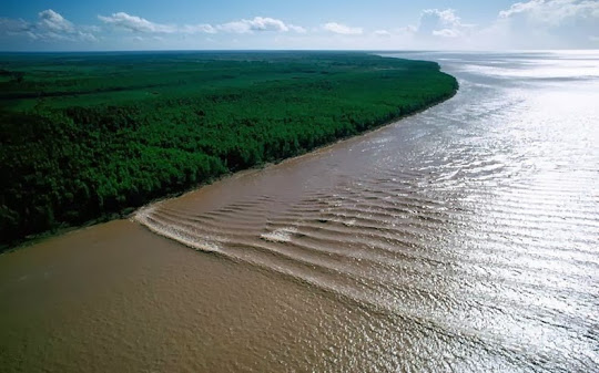
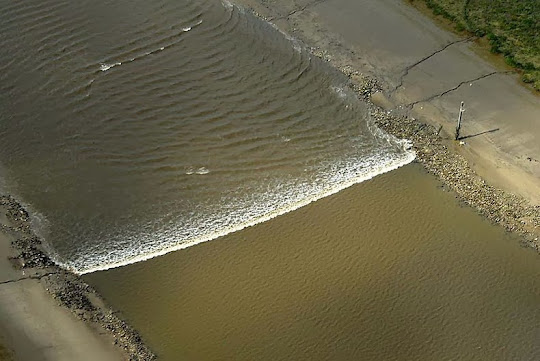
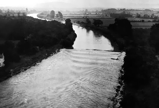
A view of the Severn Bore, sweeping down the river Severn between Stonebench and Minsterworth, in Gloucestershire, England, on September 3, 1936. At times the waves reached a height of 20 feet.


Source
READ MORE»

Forgotten Pharaoh Found in Egypt

U.S. archaeologists digging at Abydos, Egypt say they have discovered the tomb of Woseribre-Senebkay, a previously unknown Egyptian pharaoh who ruled during the Second Intermediate Period, shortly before 1650 BC.


The cartouche of a newly discovered pharaoh, Woseribre Senebkay, inside the king’s burial tomb. Image credit: Jennifer Wegner, Penn Museum.

The excavations at Abydos during the 2013 season have yielded numerous finds including a royal tomb with a large sarcophagus weighing almost 60 tons.

The tomb was uncovered close to the recently discovered tomb of Sobekhotep (1780 BC), the first king of 13th Dynasty.

According to the archaeologists from the University of Pennsylvania, the sarcophagus, of red quartzite quarried and transported to Abydos from Gebel Ahmar, near Cairo, dates to ca. 1650 BC.


Painted decoration in the burial chamber of the pharaoh Woseribre Senebkay. Image credit: Jennifer Wegner, Penn Museum.

They identified it as belonging to a previously unknown pharaoh named Woseribre Senebkay – one of the earliest kings of a forgotten Abydos Dynasty, contemporary with the 15th (Hyksos) and 16th (Theban) Dynasties. The existence of this dynasty was first hypothesized by Prof Kim Ryholt from the University of Copenhagen in 1997.

The tomb of Senebkay consists of 4 chambers with a limestone burial chamber, painted with images of the goddesses Nut, Nephthys, Selket, and Isis flanking the ruler’s canopic shrine.

Other texts name the sons of Horus and record the king’s titulary and identify him as the ‘king of Upper and Lower Egypt, Woseribre, the son of Re, Senebkay.’

The tomb was badly plundered by ancient robbers who had ripped apart the king’s mummy as well as stripped the tomb equipment of its gilded surfaces.


Close up of Penn Museum excavations of a recently discovered royal chamber at Abydos, Egypt, June 2013. The discovery of this chamber led researchers to the nearby tomb of a previously unknown pharaoh, Woseribre Senebkay. Image credit: Josef Wegner, Penn Museum.

Nevertheless, the archaeologists recovered the Senebkay’s remains amidst debris of his fragmentary coffin, funerary mask, and canopic chest.

Preliminary work on the king’s skeleton indicates he was a man of moderate height, around 1.75 m, and died in his mid to late 40s.

According to the team, the discovery of Senebkay now identifies the location of the Abydos Dynasty’s royal necropolis at South Abydos in an area anciently called Anubis-Mountain.

The kings of this dynasty placed their burial ground adjacent to the tombs of earlier Middle Kingdom pharaohs. There is evidence for about 16 royal tombs spanning the period 1650-1600 BC.

The scientists say the Senebkay’s name may have appeared in a broken section of the famous Turin King List, a papyrus dating to the reign of Ramses II, 1200 BC, where two kings with the throne name ‘Woser … re’ are recorded at the head of a group of more than a dozen kings, most of whose names are entirely lost.


A painted scene of the goddesses Neith and Nut, protecting the canopic shrine of the pharaoh Woseribre Senebkay. Image credit: Jennifer Wegner, Penn Museum.

The tomb of pharaoh Senebkay is modest in scale. An important discovery was the badly decayed remains of Senebkay’s canopic chest. This chest was made of cedar wood that had been reused from the nearby tomb of Sobekhotep I and still bore the name of that earlier king, covered over by gilding.

Such reuse of objects from the nearby Sobekhotep tomb by Senebkay, like the reused sarcophagus chamber found during the summer, provides evidence that suggests the limited resources and isolated economic situation of the Abydos Kingdom which lay in the southern part of Middle Egypt between the larger kingdoms of Thebes and the Hyksos in northern Egypt.

Unlike these numbered dynasties, the pharaohs of the Abydos Dynasty were forgotten to history and their royal necropolis unknown until this discovery of Senebkay’s tomb.

“It’s exciting to find not just the tomb of one previously unknown pharaoh, but the necropolis of an entire forgotten dynasty,” said team leader Dr Josef Wegner of the Penn Museum.

“Continued work in the royal tombs of the Abydos Dynasty promises to shed new light on the political history and society of an important but poorly understood era of Ancient Egypt.”


Source
READ MORE»