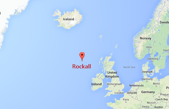
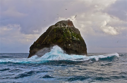
Rockall is a very small, unremarkable and uninhabited rocky island located around 480 km off the west coast of mainland Scotland. At just over 25 meters wide by 21 meters high, the extinct volcanic plug doesn’t seem to have any outstanding features of particular interest. Yet, this tiny island has been at the center of an international dispute for over half a century. Four nations - the UK, Ireland, Iceland and Denmark, have all stalked claim on the island. Why would anyone be so keen on a piece of rock in the middle of nowhere? The answer lies in the vast tracts of surrounding fisheries and the huge oil and gas reserves hidden in the surrounding seabed.
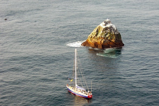
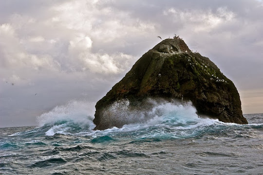
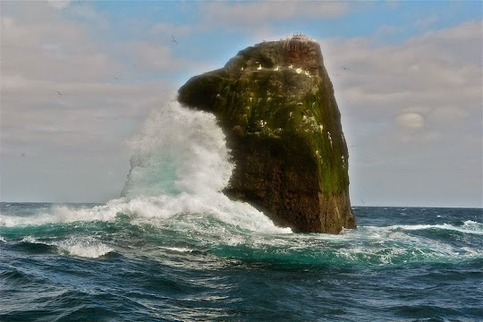
Rockall is a pyramid of volcanic granite that juts out of the Atlantic like the fin of a gigantic shark. The sea here is so tempestuous, that is almost impossible to determine the island’s height: somewhere between 20 and 30 meters above sea level. The island's only permanent inhabitants are common periwinkles and other marine molluscs. Small numbers of seabirds use the rock for resting in summer or occasionally breed successfully if the summer is calm with no storm waves washing over the rock.
Although there are written references to the rock since at least the 16th century, the first known landing on Rockall did not occur until the early 19th century. Those responsible for carrying it out were the crew of the HMS Endymion in 1811. Not long after the visit of Endymion, the exact position of Rockall was included in the charts of the time, which did not stop the steamer named SS Norge from running aground in 1904 causing the loss of 635 lives, the biggest disaster on the island.
Much later, in September 21, 1955, a Royal Navy helicopter landed on the tiny island and deposited there three soldiers and a scientist, who proceeded to hoist a Union Flag and set with cement plate whereby taking possession of the place on behalf of Her Majesty Queen Elizabeth II. In 1972, The Island of Rockall Act was passed by parliament, formally declaring the island a part of the United Kingdom. But that claim has not been officially recognized by any other state.
British imperial ambitions suffered a set back by the international ratification of the Law of the Sea in 1982, which states: "Rocks which cannot sustain human habitation or economic life of their own shall have no exclusive economic zone or continental shelf."
In order to prove Rockall can sustain habitation, and therefore is a sovereign part of British territory, a former SAS soldier Tom McClean lived on the barren rock for a record 40 days in 1985. This feat of endurance was broken in 1997, when Greenpeace activists landed on the island and spent 42 days on it as a publicity stunt. They claimed Rockall as a micro-nation and renamed it Waveland. They even unscrewed the 1955 plaque and re-fixed it back-to-front.
Britain's claim to the islet hasn’t gone down well on many Irish, inspiring the Irish music group Wolfe Tones to compose a patriotic track titled “Rock On Rockall” that goes:
Oh rock on Rockall, you'll never fall to Britain's greedy hands
Or you'll meet the same resistance that you did in many lands
May the seagulls rise and pluck your eyes and the water crush your shell,
And the natural gas will burn your ass and blow you all to hell.
Source
READ MORE»
Rockall is a pyramid of volcanic granite that juts out of the Atlantic like the fin of a gigantic shark. The sea here is so tempestuous, that is almost impossible to determine the island’s height: somewhere between 20 and 30 meters above sea level. The island's only permanent inhabitants are common periwinkles and other marine molluscs. Small numbers of seabirds use the rock for resting in summer or occasionally breed successfully if the summer is calm with no storm waves washing over the rock.
Although there are written references to the rock since at least the 16th century, the first known landing on Rockall did not occur until the early 19th century. Those responsible for carrying it out were the crew of the HMS Endymion in 1811. Not long after the visit of Endymion, the exact position of Rockall was included in the charts of the time, which did not stop the steamer named SS Norge from running aground in 1904 causing the loss of 635 lives, the biggest disaster on the island.
Much later, in September 21, 1955, a Royal Navy helicopter landed on the tiny island and deposited there three soldiers and a scientist, who proceeded to hoist a Union Flag and set with cement plate whereby taking possession of the place on behalf of Her Majesty Queen Elizabeth II. In 1972, The Island of Rockall Act was passed by parliament, formally declaring the island a part of the United Kingdom. But that claim has not been officially recognized by any other state.
British imperial ambitions suffered a set back by the international ratification of the Law of the Sea in 1982, which states: "Rocks which cannot sustain human habitation or economic life of their own shall have no exclusive economic zone or continental shelf."
In order to prove Rockall can sustain habitation, and therefore is a sovereign part of British territory, a former SAS soldier Tom McClean lived on the barren rock for a record 40 days in 1985. This feat of endurance was broken in 1997, when Greenpeace activists landed on the island and spent 42 days on it as a publicity stunt. They claimed Rockall as a micro-nation and renamed it Waveland. They even unscrewed the 1955 plaque and re-fixed it back-to-front.
Britain's claim to the islet hasn’t gone down well on many Irish, inspiring the Irish music group Wolfe Tones to compose a patriotic track titled “Rock On Rockall” that goes:
Oh rock on Rockall, you'll never fall to Britain's greedy hands
Or you'll meet the same resistance that you did in many lands
May the seagulls rise and pluck your eyes and the water crush your shell,
And the natural gas will burn your ass and blow you all to hell.
Source