Azerbaijan, located within the South Caspian Sea basin, is among the world's oldest oil producers. The petroleum industry in Azerbaijan produces about 800,000 barrels of oil per day and 1 billion cubic meters of gas per year. There is so much oil and natural gas reserve under the Absheron Peninsula that the ground practically leaks all over.
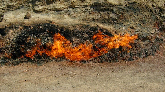
Throughout Azerbaijan, numerous fires have been burning since antiquity and these were reported on by historical writers such as Marco Polo in the 13th century, and later by the famed writer Alexandre Dumas, who described a Zoroastrian fire temples built around a natural fire. This phenomenon of spontaneous fire caused by gas seepage have given Azerbaijan the moniker "Land of Fire." It also created a cult of fire worshippers – the Zoroastrians, which first appeared in this region over 2,000 years ago before the Islamic rule came into effect. Numerous references to fire can also be found in Azerbaijan’s folklore and culture.
There are at least three places where one can observe Azerbaijan’s famous fires.
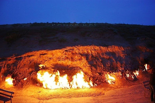
Yanar Dag, the burning mountain, in Azerbaijan.
Yanar Dag
Yanar Dag, which literally translates to "burning mountain", is a natural gas fire which blazes continuously on a hillside near Baku, the capital of Azerbaijan. Flames jet out into the air 3 meters from a thin, porous sandstone layer. Around this open fireplace the atmosphere is filled with the smell of gas. The naturally occurring fire burns in colorful flames most impressively at dusk, when both tourists and locals can view it from nearby teashops.

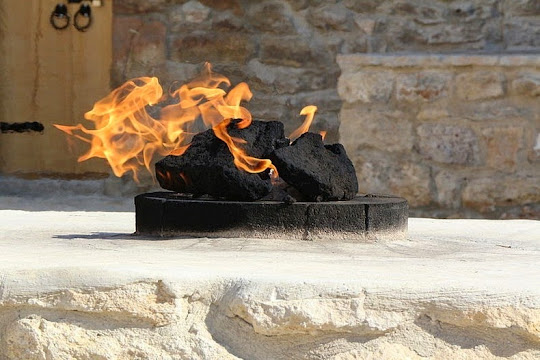
Ateshgah of Baku
The Ateshgah of Baku near Baku, off the Greater Caucasus, is another famous site of Azerbaijan’s eternal fires. Ateshgah means “temple of fire”. This pentagonal complex, which has a courtyard surrounded by cells for monks and a tetrapillar-altar in the middle, was built during the 17th and 18th centuries. The fire was once fed by a vent from a subterranean natural gas field located directly beneath the complex, but heavy exploitation of the natural gas reserves in the area during Soviet rule ended the flow of natural gas to the temple and extinguished the holy fire in 1969.
The temple was converted into a museum soon after the fire went out. Today, the fire that can seen here is fed by mains gas piped from Baku city.

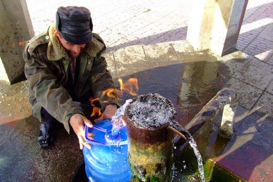
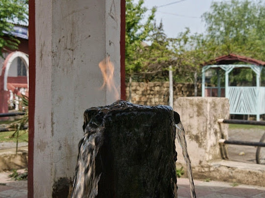
Yanar Bulag
Yanar Bulag or the "burning spring" is located to the city of Astara in southern Azerbaijan. It consist of a metal stand pipe inside a small pavilion through which water comes gurgling out. It looks nothing unusual, but when you light a match and touch the water, the water itself is set ablaze. This occurs due to the water’s high methane content.
The locals believe the water from the spring has remedial properties, and would often take a drink while the flame is alit. There are always people at the spring who stop by to fill their bottles and carry on their journeys.
Source
READ MORE»
Throughout Azerbaijan, numerous fires have been burning since antiquity and these were reported on by historical writers such as Marco Polo in the 13th century, and later by the famed writer Alexandre Dumas, who described a Zoroastrian fire temples built around a natural fire. This phenomenon of spontaneous fire caused by gas seepage have given Azerbaijan the moniker "Land of Fire." It also created a cult of fire worshippers – the Zoroastrians, which first appeared in this region over 2,000 years ago before the Islamic rule came into effect. Numerous references to fire can also be found in Azerbaijan’s folklore and culture.
There are at least three places where one can observe Azerbaijan’s famous fires.
Yanar Dag, the burning mountain, in Azerbaijan.
Yanar Dag
Yanar Dag, which literally translates to "burning mountain", is a natural gas fire which blazes continuously on a hillside near Baku, the capital of Azerbaijan. Flames jet out into the air 3 meters from a thin, porous sandstone layer. Around this open fireplace the atmosphere is filled with the smell of gas. The naturally occurring fire burns in colorful flames most impressively at dusk, when both tourists and locals can view it from nearby teashops.
Ateshgah of Baku
The Ateshgah of Baku near Baku, off the Greater Caucasus, is another famous site of Azerbaijan’s eternal fires. Ateshgah means “temple of fire”. This pentagonal complex, which has a courtyard surrounded by cells for monks and a tetrapillar-altar in the middle, was built during the 17th and 18th centuries. The fire was once fed by a vent from a subterranean natural gas field located directly beneath the complex, but heavy exploitation of the natural gas reserves in the area during Soviet rule ended the flow of natural gas to the temple and extinguished the holy fire in 1969.
The temple was converted into a museum soon after the fire went out. Today, the fire that can seen here is fed by mains gas piped from Baku city.
Yanar Bulag
Yanar Bulag or the "burning spring" is located to the city of Astara in southern Azerbaijan. It consist of a metal stand pipe inside a small pavilion through which water comes gurgling out. It looks nothing unusual, but when you light a match and touch the water, the water itself is set ablaze. This occurs due to the water’s high methane content.
The locals believe the water from the spring has remedial properties, and would often take a drink while the flame is alit. There are always people at the spring who stop by to fill their bottles and carry on their journeys.
Source