The Painted Dunes in Lassen Volcanic National Park

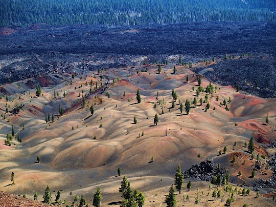
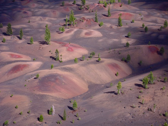
The Painted Dunes are multicolored pumice fields formed by oxidation of volcanic ash as they fell out of volcanic eruptions that have sculpted the area inside Lassen National Park in Northern California. The ash on Painted Dunes is brightly oxidized because it fell on lava flows when they were still hot. The Painted Dunes, along with Fantastic Lava Beds, and other eccentric geological features lie near Cinder Cone, a 700-foot tall cinder cone volcano that’s believed to have last erupted in 1650s.

Cinder Cone is composed of loose scoria – a material which began as blobs of gas-charged lava thrown into the sky during an eruption, but fell as hardened volcanic rock containing cavities created by trapped gas bubbles. Later, like many cinder cones, it was snuffed out when several basalt lava flows erupted from its base, creating what has been named the Fantastic Lava Beds.


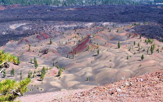
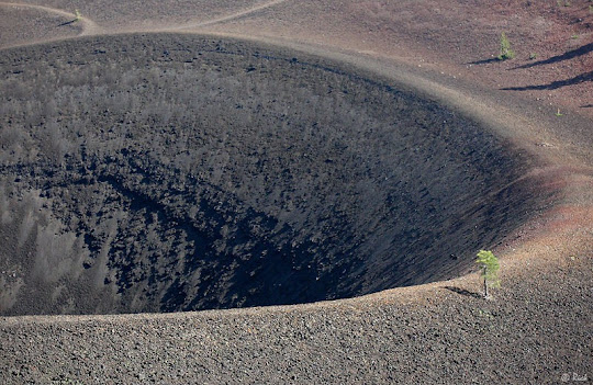
There are actually two scoria cones at Cinder Cone—the remnants of a nearly completely buried earlier cone can be seen on the larger cone's south side. Much of the earlier cone was probably destroyed by lava flows erupting from its base. The blocks of red, cemented scoria within the Painted Dunes lava flows are pieces of this earlier cone, which were carried away by the flowing lava.

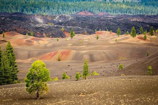
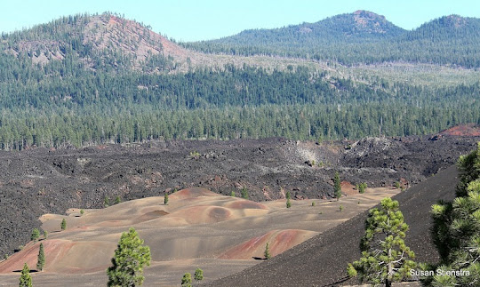
There is a great hiking trail to the top of Cinder Cone from where you can marvel at the landscape transformed by volcanic activity. Climbing the cone is a challenge because of all the loose rocks that keep sliding you down. Painted Dunes is located down the South East face of the cone, and just beyond the Fantastic Lava Beds.
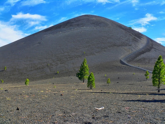


Cinder Cone.


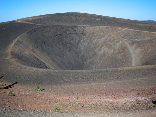
The crater on the summit.


 Source
READ MORE»

Largest Non Nuclear Explosion

At the end of the Second World War, the British Army had a huge surplus of ammunition and explosives that started to give them ideas. It was suggested that the excess ammunition could be utilized for seismic experiments by setting up controlled explosions to generate seismic waves having intensity comparable with those produced by small earthquakes. It was impractical to carry out the experiments within England as explosion of the necessary size on the available sites would cause damage to nearby properties. So they turned to Germany.

The British had just concluded the biggest war in human history with Germany, and like the explosives, aggression was still in surplus quantities. In July 1946, an ammunition dump near the town of Soltau, in north Germany, was blown up producing seismic waves that were observed at distances up to 50 km. But the British needed something bigger. So they started preparing for the world’s most powerful non-nuclear explosion, which eventually came to be known as the “British Bang”. The target: a small archipelago off the German coastline called Heligoland.


Heligoland is a small archipelago located about 46 kilometers off the German coastline in the North Sea. It consist of two islands – the populated one square km main island, Hauptinsel, and an uninhabited smaller island alongside named ‘Dune’ where the island’s airstrip is located.

Because of its strategic location, Heligoland has a long military history. Originally occupied by Frisian herdsmen and fishermen, the island came under the control of the dukes of Schleswig-Holstein in 1402 and became a Danish possession in 1714. In 1807, during the Napoleonic wars, Heligoland was seized by the British fleet and formally ceded to Great Britain in 1814. In 1890, the island was transferred to Germany in exchange for Zanzibar and other African territories.


Birdseye view of Helgoland, between 1890 and 1900. 


N.E. Point, Helgoland, between 1890 and 1900. 

The Germans evacuated the civilian population living on the island and developed the island into a major naval base, with extensive harbor and dockyard installations, underground fortifications, and coastal batteries. The first naval engagement of the war, the Battle of Heligoland Bight, was fought near this island. When the First World War ended, the islanders returned and the island became a popular tourist resort for the German upper class. During the Nazi era, the island was again made a naval stronghold and sustained severe Allied bombing toward the end of World War II.

With the defeat of Germany, the population was evacuated, and the British decided to destroy the remaining fortifications, underground bunkers and submarine base by deep blasting, and at the same time record the explosion with seismic sensors for science.

On 18 April 1947, the Royal Navy detonated 6,700 tons of explosives creating a black mushroom cloud that curled 6,000 feet into the sky. People on the mainland 60 km away were warned to open their windows to avoid implosion, and the blast was registered as far away as Sicily. The Guinness Book of World Records lists the Heligoland explosion as the world’s largest single non-nuclear explosion in history.


The explosion at Heligoland

The detonation which released energy equivalent to a third of that released by the Hiroshima atomic bomb, shook the main island several miles down to its base. The British originally expected the island to be totally destroyed. The island survived but it’s physical shape was altered for ever. Its southern tip caved in to a huge crater, that is today a celebrated tourist spot.

The Royal Air Force continued to use the island as a bombing range until it was returned to West Germany on March 1, 1952. The town, the harbor, and the bathing resort on Düne were rebuilt, and Heligoland once again became a holiday resort.


Seals resting on the beach of Düne


Lots of birds on the cliffs of Helgoland. 


Source
READ MORE»